Executive Summary
Welcome to Satcom series 2 – in this blog we will discuss on basic understanding of satellite orbits, its’s simulation/near real time propagator techniques – overview of 5G and satellites integrated view ,use of Machine Learning on available open satellite data
Following are the categories the blog has been segregated
- Satellite Orbit
- TLE (Two lines elements) and orbit propagator
- Use of Machine Learning with example
- 5G and satellite as a integrated view
Satellite Orbit
Quick recap on types of orbit as – we can broadly ctegorized as Satellite orbit types
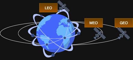
Fig 1 : Types of Orbit
GEO (~ stationary with respect to earth ,altitude ~36000 km)
MEO ( not synchronized with earth roation ,altitude ~ 5500 -12000 km )
LEO (not synchronized with earth rotation,altitude ~500 -900 km)
Two Line Elements (TLE)
- Two-line elements is a standardised format used to describe the orbit of a satellite. They consist of a set of data that includes important orbital parameters, such as the satellite’s position, velocity, and other relevant information at a specific epoch or time.
- The TLE format was developed to provide a compact and standardised way to convey essential orbital data for tracking and predicting the motion of satellites for public use.
- A typical TLE consists of two lines of text. The first line, known as the “line 1,” provides information such as the satellite’s name or identification number, the International Designator, the epoch time (the specific time at which the orbital parameters are valid), and certain orbital elements like the inclination, right ascension of the ascending node, and eccentricity.
- The second line, known as the “line 2,” includes additional orbital parameters like the argument of perigee, mean anomaly, mean motion, and revolution number. These parameters, along with the data from the first line, allow for precise calculation of the satellite’s position and velocity at any given time.
- TLE data is generated based on observations from ground-based tracking stations, radar systems, or other tracking methods. These observations are processed to determine the satellite’s orbital elements, which are then encoded into the TLE format. It’s important to note that TLE data is time-sensitive and needs to be regularly updated to account for orbital perturbations and changes in the satellite’s orbit.
Two Lines elements is the common language model for describing orbits of a satellite, in this blog we will use SGP4 implementation and also understand the history of TLE.
Why Is It Required?
- Different space organisation use their own methods to track satellite and which is very accurate and complicated in nature.hence there has to be some common language which is simple, easy to understand and can be agreed to use all space agencies, hence TLE was introduced.
- TLE remains the most widely used format for distributing general-purpose orbital data due to its ubiquity and simplicity despite its limitation on accuracy.
- Now We go back to history and find out Kepler’s observation which is a foundation for TLE algorithm and space dynamics.
Kepler’s laws of planetary motion
Kepler’s 1st laws:The orbits of the planets are ellipses, with the Sun’s centre of mass at one focus of the ellipse
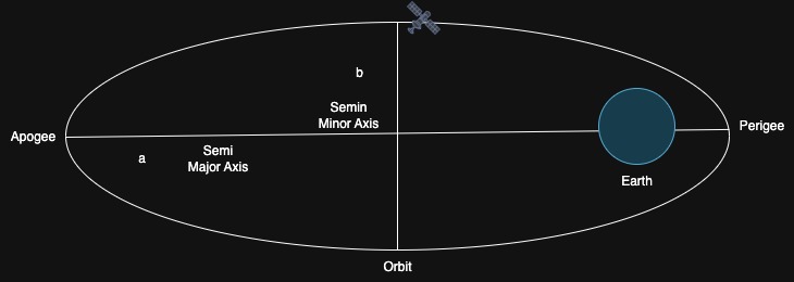
Fig2 : Kepler’s 1st Law
in our context – sateelite is roating around earth in a eliptical format and it has two focal points – closeset point to earth is called Perigee and farest to earth is called perigee.
- Semi major axis – distance betwwen ellipse centre to farest point denoted by a
- semi minor axis – Distance between center and closest point in ellipse denoted by b
- Eccentricity ( e ) = √1-b^2/a^2
Kepler’s 2nd laws: An imaginary line connecting a planet to the Sun sweeps out equal areas in equal amounts of time. This means a planet moves faster when it is closer to the Sun (at perihelion) and slower when it is farther away

Fig2 : Keplar’s 2nd Law
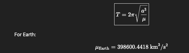
Kepler’s 3rd laws the square of a planet’s orbital period is directly proportional to the cube of the semi-major axis of its orbit
Where
- T = orbital period (seconds)
- a= semi-major axis of the orbit (km or m)
- G = gravitational constant
- M = mass of the central body
- μ =(gravitational parameter)
For more information on Kepler’s law orbits-and-keplers-laws
Orbital elements -necessary elements to plot satellite position in orbit
- An elliptical orbit can be described by the 6 parameters with assumption satellite orbits earth without any deviation.
- These 6 parameters are necessary to identify the orbital position of a satellite with respect to a reference point – The Earth-centered inertial (ECI) inertial (ECI) system is considered non-rotating and is generally treated as inertial for most applications, despite the equinox and equatorial plane experiencing very slight movements over time. For high-precision orbit calculations, the ECI system is recognized as truly inertia
For more information on co-ordinate system : Coordinate system

Fig 3 : Simplified version of 6 orbital parameters of a satellite orbit
TLE Format
1 42747U 17031A 25337.43994899 .00000143 00000-0 00000+0 0 9998
2 42747 0.1133 91.3642 0003168 121.1733 66.2519 1.00272883 31188
| Column | Example | Meaning |
| 1 | 1 | Line number (must be 1) |
| 3–7 | 42747 | Satellite Catalog Number (NORAD ID) |
| 8 | U | Classification (U=Unclassified, C=Classified, S=Secret) |
| 10–17 | 17031A | International Designator: YYNNN[A-Z] → 17=year 2017, 031=satellite number, A=piece |
| 19–32 | 25337.43994899 | Epoch in YYDDD.DDDDDDDD format → year 2025, 337th day, 43994899 fractional day |
| 34–43 | .00000143 | First time derivative of mean motion (n-dot) → how fast the mean motion changes, in rev/day² |
| 45–52 | 00000-0 | Second derivative of mean motion (n-double-dot), usually in scientific notation (00000-0=0.0) |
| 54–61 | 00000+0 0 | BSTAR drag term (atmospheric drag) in scientific notation → 0.29623 × 10^-4 |
| 63 | 0 | Ephemeris type (0=SGP4/SDP4) |
| 65–68 | 999 | Element set number (incremented for each update) |
| 69 | 8 | Checksum for line 1 (modulo 10, sum of digits + ‘-‘ counts as 1) |
| Column | Example | Meaning |
| 1 | 2 | Line number (must be 2) |
| 3–7 | 42747 | Satellite Catalog Number (matches Line 1) |
| 9–16 | 0.1133 | Inclination (i) in degrees |
| 18–25 | 91.3642 | Right Ascension of Ascending Node (RAAN, Ω) in degrees |
| 27–33 | 0003168 | Eccentricity (e) → decimal point assumed (0.0005560) |
| 35–42 | 121.1733 | Argument of perigee (ω) in degrees |
| 44–51 | 66.2519 | Mean anomaly (M) in degrees |
| 53–63 | 1.00272883 | Mean motion (n) in rev/day |
| 64–68 | 3118 | Revolution number at epoch (rev) |
| 69 | 8 | Checksum for line 2 (modulo 10) |
SGP4 implementation (As a observer view point)
The Keplerian orbit propagator relies on a simplified model that considers only the gravitational field of the Earth and ignores the effects of other celestial bodies and environmental factors. This model assumes that the Earth is spherical with a uniform density. This approach makes this propagator the least accurate.
In contrast, the SGP4 orbit propagator incorporates both secular and periodic orbital disturbances due to the Earth’s shape and atmospheric drag, making it suitable for satellites in near-Earth orbit with orbital periods less than 225 minutes. When the orbital period of the satellite is greater than 225 minutes, the SGP4 orbit propagator additionally accounts for solar and lunar gravity.
Earth station is a observer and a reference point for satellite orbit .Over time, the position of satellite deviates from that of Keplerian TLE because for secular and periodic orbital perturbations caused by Earth’s geometry and atmospheric drag.
Periodic perturbations are generally oscillatory (like a sine wave) from a reference view point -which is a earth station and the scenario can be simulated using SGP4 plot and multiple TLE’s can provide phase shift due to earth and celestial’s environment factor into consideration.
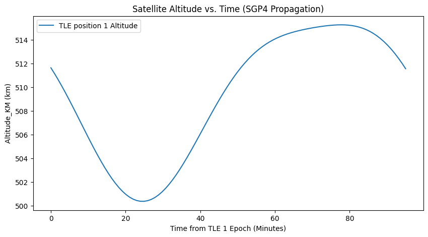
Fig 4 : SGP4 implementation of single TLE (TLE1) of a live satellite CARTOSAT-2F (ISRO)

Fig 5 phase difference due to earth and celestial bodies environmental factors – TLE(s) of same satellite in SGP4 propagator.
Machine learning Initial Step :Orbital Data Set
Initial step – We have used Decision Tree Regression on prepared test data set of live satellite orbital data for features importance within data set.
Please note – split details taken at level 3 for visualization and learning purpose only. – while code is use full grown Decision Tree for feature analysis.
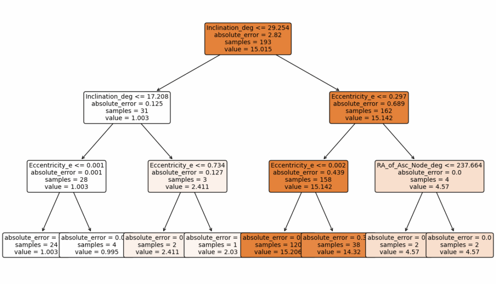
Fig 6 – Data set use Decision Tree Regression and its split criteria.

Fig 7 : features importance analysis on data set
| Parameter | TLE Line | Physical Meaning | Role in Orbit |
| Inclination | 2 | Tilt of the orbit. The angle between the orbital plane and the Earth’s equatorial plane. | Defines the latitude extremes the satellite will pass over. |
| RA of Ascending Node | 2 | Orientation in the equator. The angle measured eastward in the equatorial plane from the vernal equinox (reference direction) to the point where the satellite crosses the equator moving North (Ascending Node). | Defines where the orbital plane is positioned in space. |
| Eccentricity | 2 | Shape of the orbit. Defines how elliptical the orbit is. | e=0 is a perfect circle; 0 < e < 1is an ellipse. Determines the difference between apogee (highest point) and perigee (lowest point). |
| Arg of Perigee | 2 | Orientation within the plane. The angle, measured in the orbital plane, from the Ascending Node to the perigee (closest point to Earth). | Defines the orientation of the ellipse within the orbital plane. |
| Mean Anomaly | 2 | Satellite’s position. The theoretical position of the satellite in its orbit, measured from perigee, assuming perfectly uniform circular motion. | Defines where the satellite is located along the orbital path at the TLE’s epoch time. |
| Parameter | TLE Line | Physical Meaning | Role in Prediction |
| Mean Motion | 2 | Orbital Speed/Size. The number of complete revolutions the satellite makes in one sidereal day. | Defines the orbit’s size (semi-major axis). A higher Mean Motion means a faster, lower-altitude orbit. |
| BSTAR | 1 | Atmospheric Drag Coefficient. A simplified, lumped parameter that models the effect of atmospheric drag on the satellite’s motion. | Adjusts the orbital decay rate. The higher the value, the greater the drag effect the SGP4 model applies to the orbit. |
We will cover implementation of ensemble ML/ANN/RNN model in future blog(s) with larger data set.
Integrated 5G and Satcom overview: Non-terrestrial networks (NTN)
Non-terrestrial networks (NTN) are networks or segments of networks that use either Unscrewed Aircraft Systems (UAS) operating typically between 8 and 50km altitudes, including High Altitude Platforms (HAPs) or satellites in different constellations to carry a transmission equipment relay node or a base station:
Two types of modes or “payload” can be distinguished, see also Figure 2:
- Non-regenerative payload (also called “bentpipe payload” (considering the path from the gateway via spaceborne/airborne platform to the UE) or “transparent mode”): A spaceborne/airborne platform with no on-board processing capabilities that changes the frequency carrier of the received uplink RF signal, filters and amplifies it before transmitting it on the downlink, i.e. the platform corresponds to an analogue RF repeater;
- Regenerative payload (or non-transparent mode): a spaceborne/airborne platform that has on top of RF filtering, frequency conversion and amplification also on-board processing capabilities (for demodulation/decoding, switching and/or routing, coding/modulation) so this spaceborne/airborne platform has base station functions on board.
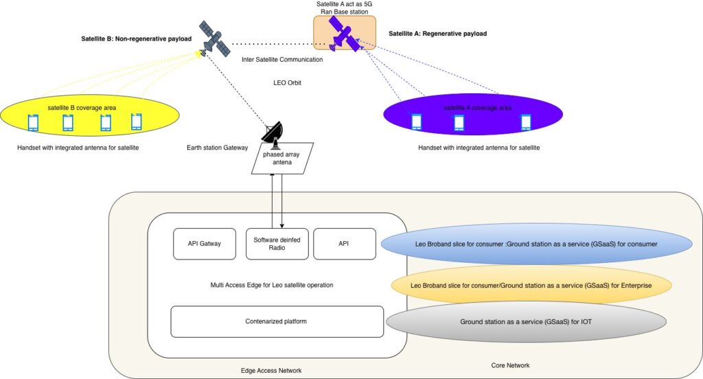
Fig 7 : Integrated 5G with Satellite view – satellite act as a 5G NR over NTN
Conclusion
Hope, we can able to provide overview of satellite orbit ,Two line element and SGP4 implementation including data pattern recognition using machine learning function. As satellite is becoming a integral part of 5G NR , so we might need data driven algorithm or preferably use of different flavour of artificial intelligence to manage and visualize network – in terms of predictive planning context with more and more parameters will be required in optimised sate. It might also required TLE to be part of next generation planning.
upcoming blog(s)
Dedicated blog for use of machine learning and deep learning with orbital data ,modulation techniques, Encryption ,security viewpoint, 5G and NTN, link budget
Happy learning !
GitHub link
https://github.com/soumyaraja/tle-sgp4-analyser
https://github.com/soumyaraja/satellite-orbital-ML-Analyser
Ref Link
https://www.3gpp.org/technologies/ntn-overview
For live satellite data download : https://www.space-track.org
Live satellite track https://www.n2yo.com
https://arxiv.org/html/2207.08993v4
https://arxiv.org/html/2402.04830v4
https://www.sciencedirect.com/topics/engineering/geosynchronous-orbit
https://www.mathworks.com/help/aeroblks/coordinate-systems-for-modeling.html